Perhaps the most mythologized episode of the US Cavalry of the late 1800s is the Battle of the Little Bighorn, otherwise known as Custer's Last Stand. The date was June 25th and 26th, 1876 -- the same year Alexander Graham Bell invented the telephone, a mere 100 years after America declared its independence from Britain, and less than a 100 years before man was walking on the moon!
The battle occurred as a result of several Indian tribes refusing to abandon their nomadic lifestyle and the subsequent decree by the US Government that wandering tribes should be returned to their designated reservations, forcibly if necessary. As we all know, none of this ended well. The 'battle', actually a series of skirmishes played out over a five mile stretch of Montana grass plain, represented a final, defiant gesture by the Indian warrior culture and was, essentially, the beginning of the end of the Indian tribes as a military force.
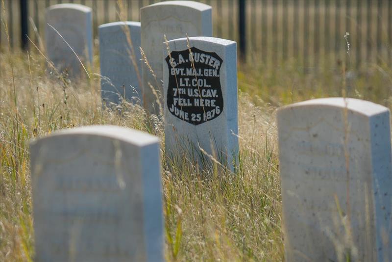 |
| The marker for Lt. General George Custer on 'Last Stand Hill' |
Strangely, this story was well known to me as an English schoolboy (how, I can't quite remember) but seems not to be part of contemporary education. The 'battle' has been described in hundreds of books, paintings, articles and movies (involving Erroll Flynn and John Wayne among others.) As they say 'the truth is out there' and much of that material doesn't paint a very accurate historical picture.
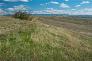
The Little Bighorn is actually a river flowing through south eastern Montana and the battle took place mostly on the northern side of the river in a grassy plains area full of rolling hills, small canyons and some woods. Today, Interstate 90 and 94 run right by the National Park site but the surrounding countryside is very lightly populated and you have to believe that it is not much changed from Custer's day.
Contrary to popular belief, Custer initiated the confrontation as part of his mandate to return the defiant tribes to their reservation. One of his companies came across a large encampment of, primarily, Lakota Sioux and Cheyenne and proceeded to engage a small band of roaming tribesmen. Quickly they figured out that there were many, many more Indians than they had thought and had to beat a hasty retreat. They were pursued into the woods and across the river, setting into motion the tragic chain of events on that day. Hearing of this Custer, who was 20 miles away at the time, proceeded to ride into battle in support of the beleagured company, ignoring the advice of his scouts who had tried to convince him of the folly of an attack, given the size of the opposing force.
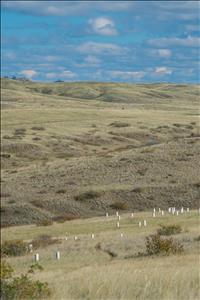
A series of skirmishes along five miles of a small ridge culminated in the storied 'Last Stand' where Custer and 41 men around him lost their lives. Most of Custer's initial 700 men under his command were killed although there were survivors, including a horse -- present at the Last Stand -- which subsequently did several years of service as a regimental mascot.
Today the battle locations are marked out along this stretch of grassland with individual markers placed at the location where men fell, their actual graves being in a designated military graveyard close to the site of the Last Stand. How were these sites determined? Excellent question. Many of them could only be accurately sited after a 1983 fire exposed the bare land and a team of historian archeologists was able to examine the site in great detail, uncovering both human remains and many other artefacts.
For the historical truth, as best it can be determined, in (overwhelming) detail read 'A Terrible Glory'. For a more detailed synopsis and links to many other sources, see the Wikipedia entry
More images are in this gallery.